If Only Somebody Had Told Me…

Cascadian Abroad

Most of the posts on Cascadian Abroad are very positive and reflect our experiences honestly and accurately. Some of the more difficult experiences (that, again honestly, make up only a small part of our time here) are usually couched with humor and sarcasm. But it hasn’t all been easy.

A few weeks ago we had an e-mail dialog with a woman back in the U.S. who was deciding whether or not to come to Japan to teach next spring. It was an interesting thread as it really made us think about the experience so far and what we wish we would have known before we made the decision to come to Japan. Her and her fiancé are in a similar position as we were back in our decision-making process, so we were happy to provide some information. 

Had we known these things in advance, it wouldn’t have changed our decision to come and actually might have expedited our decision while helping us better prepare for the move. I’d like to share some of those things today. 

Finding a job in Japan will be difficult

Since her spouse was also leaving a career in the U.S., they had questions about finding work. My visa allows me to work up to 28 hours per week, but finding a part-time job isn’t an easy task. Most English-speaking jobs in our area still require at least business-level knowledge of Japanese. I’m still working up to toddler-level Japanese, so most of those opportunities are off the table. The couple of contacts I’ve made have projects that are “in the works,” but they are moving on Japan Time, which is akin to Island Time.

Not very many people speak English

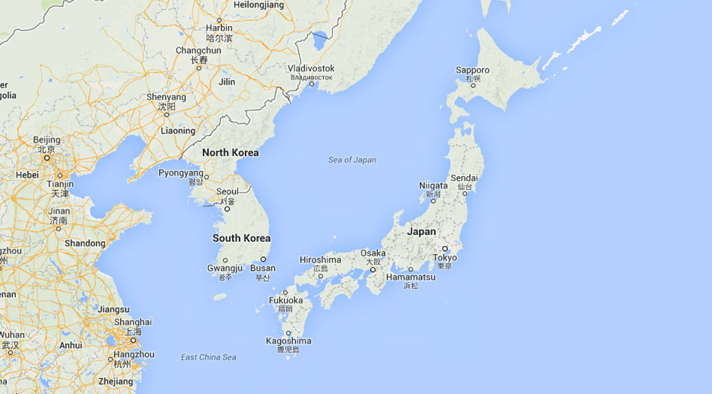
Americans are pretty ethnocentric (although I think it’s not just Americans), so prior to coming to Japan, we got a lot of “Don’t worry, they’ll probably speak English.” That may be true in parts of Tokyo or other large cities, but where we live, it’s just not the case. Some people learned a little bit in school, much like we speak a little bit of Spanish or French or whatever language class we took for two years in high school. Those who know a little are more than happy to try and communicate with you, but (no duh!) I’ve found that I need to learn Japanese to communicate in Japan.

Our adventure started in a whirlwind fashion, but I think if we had more time it would have been helpful to take Japanese classes in the U.S. with English-speaking teachers. When you’re starting from scratch, or rebooting nearly 20 years removed from high school Japanese, learning in-context is tough, especially with a language not based in a Latin/Roman script.

People will stare at you

One thing that alternately annoys me and fascinates me is that we stick out like a sore thumb in our neighborhood. Some people are interested, some stare with suspicion, some children cry and scramble into their parents’ arms (all true stories). The suspicious stares are a little hurtful as is the feeling when a mother hastily grabs up her child when you walk by, purely because of the color of your skin (and, yes, it feels odd to write that as a Caucasian person). 

Mostly though, people are really kind to us. We were coming home from a walk today when a man came up to us and, in his best English, invited us to “this town’s festival.” Our neighborhood had a little carnival in the park. A few people smiled wide at us and greeted us. A man gave us a ticket for a kakigōri (Japanese shaved ice). A couple days ago, the druggist who helped me find cough medicine last week remembered me on our next visit and asked if the medicine helped. Many people are interested in where we’re from and I wish that I knew more Japanese to be able to answer all of their questions.

Ship a BUNCH of your favorite things

We had the opportunity to ship two large boxes about six weeks before we left the U.S. Add in a couple checked bags and our carry-ons, that’s all we would be bringing on our adventure. Trying to figure out what you’d want or need in a place you’ve never been is tough. I have way too many pairs of socks and nice pants and we’re all out of Kirkland Signature Natural Creamy Peanut Butter already. Japan’s customs restrictions mean we can’t ship a lot of our favorites products from the States, which isn’t that big a deal because it’s pretty spendy to do so anyway. But, being forced to adapt, I’ve perfected a shiitake mushroom “beef” jerky and veggie bratwurst! 

Let go and enjoy the adventure!

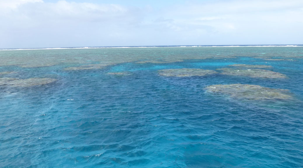
I’ll admit, I was way too uptight about some of the little things. Leaving behind everything you know isn’t easy, but the things we’ve seen over the last five months have made it all worthwhile. I know my poor wife gets a lot of “How’s Robert doing?” questions, expecting to find me huddled in a corner crying. My answer? I snorkeled the Great Barrier Reef two weeks ago, saw the Sydney Opera House last week and climbed to the summit of Mount Fuji four days ago. 

I’m fine, thanks. 

Great Barrier Reef

Great Barrier Reef

Cairns is a charming coastal town, but it’s not exactly a tourist hotspot on its own. The real draw for Cairns is that it is the gateway for the Great Barrier Reef.

The world’s largest coral reef system, the Great Barrier Reef is actually a living organism. It can be seen from space. It’s both a UNESCO World Heritage Site and one of the Seven Natural Wonders of the World. All that said, the beauty of the reef up close and personal is still understated.

Snorkelers
Geared up and ready to head into the water!

We scheduled two separate trips to the reef; one departing Cairns for the outer reef and another from Port Douglas (about 40 miles north of Cairns) bound for the Low Isles.

Bumpy Ride
The ride to the reef was a bumpy one. A good number of riders ended up seasick on the back deck.

The first trip from Cairns went out about 27 nautical miles to the Flynn, Pellowe and Thetford reefs. The weather was rainy and windy, resulting in some pretty choppy water. As we boarded the boat, we were encouraged to purchase seasickness medicine from the bar. Everyone chuckled with the certainty that WE would not be susceptible, but with the added information that all but six of the prior day’s 40 or so passengers got seasick, most popped the pills. Regardless, about half the passengers spent a good portion of the trip on the back deck filling those little white paper bags.

Fish
The water was crystal clear at the outer reef. We could see the fish swimming under the boat.

All the misery of the ride would be forgotten as soon as we reached the outer reef. As the guides on board said, nothing cures seasickness like getting in the water. The beauty that lay just beneath the water’s surface would cure most ailments.

Snorkeling
Getting my snorkel on!

Floating on the surface of the Coral Sea, the underwater paradise opened up below us. It was like a real-life Finding Nemo with a world of fish in every shape, size and color. More than 600 species of coral provided an underwater maze to explore. The coral gets its rainbow of colors from the algae that makes a home within it. “Bleaching” or whitening of the coral occurs when the coral gets stressed and expels the algae. These are real, living organisms.

Great Barrier Reef
The Great Barrier Reef colored the surface of the water, offering a subtle glimpse of the magic below.

We spent about 40 minutes at each of the three sites, guided along the way by the marine biologists who doubled as tour guides on board the boat. Along the way, we were followed by a humphead wrasse who befriended the boat seven years prior and follows it between the different reefs. In exchange for food, the fish poses for pictures with divers and snorkelers.

Sailboat
We departed Port Douglas on a sailboat headed for the Low Isles

A couple days later, we headed north to Port Douglas for a sailboat trip out to Low Island, one of the two islands that make up the Low Isles. It was a much slower, smoother trip just a few miles offshore. Low Island has an active lighthouse and the former keeper cottages are now used as research facilities by the University of Queensland.

Low Island
A view of Low Island from the boat anchored offshore

Snorkeling around Low Island offered a completely different experience. The marine biologists were amazed at how low the tide was, likely a result of the supermoon that occurred the same day.  As a result, much of the coral was above water level. As we snorkeled around the edges of the island, we often found ourselves crawling along the sea floor more than floating above it. We were literally on top of the coral in some places and ended up with a front-row seat for one of nature’s most amazing creations.

Shark and Turtle
We had several visitors around the sailboat, including a shark and a sea turtle

As we headed back to shore, we were visited by the island’s natives. A black tip reef shark circled the boat several times and a green sea turtle floated lazily by before taking off on a fast swim toward the island.

On the first trip, there was an underwater photographer who captured some of what we were seeing and while it would have been great to have an underwater camera, there’s something to be said for being able to focus on the beauty and not on capturing the perfect picture.

The two trips were so unique that it’s hard to pick a favorite. If you ever have the opportunity to visit the reef, I’d highly recommend doing something similar or maybe even adding in an introductory scuba dive. The coral and marine life were so unique in each location, I can’t imagine it would ever get old.

Readers Abroad

Cascadian Sara

Cascadian Abroad began as a way to keep friends and family updated on our adventures abroad. Over the last several months, we’ve made new friends as folks have stumbled across the blog in different ways.

I recently found out that one of those readers is my niece, Cascadian Sara! I’m so excited that she’s following along and I hope she enjoys this post!

How Far Is It? Adding Perspective in a Larger World

Japan Map

During our Australia trip, a conversation about perspective came up. Think about looking at a downtown cityscape. If you’re in the middle of the city, you see the individual streets and buildings. But if you’re 20 miles outside of town, the city becomes two-dimensional. The dozen blocks worth of buildings are now a single row of buildings.

Japan is about 142,000 square miles, similar in geographic size to Montana. From north to south, it’s roughly the northern border of Oregon to the southern border of California. But news from Japan in the U.S. flattens like the cityscape from a distance. We often get questions from friends and family as to how far away we are from natural disasters and crazy weather.

To help put our location in perspective, I prepared the following handy dandy chart showing our distance (as the crow flies) from major Japanese cities as well as a comparative distance from Portland to another U.S. city. I also added places like Sendai, which suffered major damage in the 2011 earthquake, and Ōkuma, home to the Fukushima Daiichi Nuclear Power Plant.

City Distance
from Kawagoe
U.S. City Distance
from Portland
Tokyo 20 miles Newberg, OR 21 miles
Yokohama 35 miles McMinnville, OR 34 miles
Mt. Hakone 52 miles Monmouth, OR 54 miles
Mt. Ontake, Nagano 112 miles Redmond, OR 113 miles
Ōkuma (Fukushima) 132 miles Kent, WA 130 miles
Nagoya 154 miles Redmond, WA 151 miles
Sendai 179 miles Kennewick, WA 177 miles
Kyoto 219 miles Medford, OR 221 miles
Osaka 240 miles White Rock, BC 241 miles
Kōbe 257 miles Vancouver, BC 259 miles
Iwate 276 miles Spokane, WA 289 miles
Hiroshima 412 miles Chico, CA 403 miles
Sapporo 503 miles Butte, MT 490 miles
Mt. Aso, Kyushu 523 miles San Francisco 536 miles
Fukuoka 541 miles Pocatello, ID 539 miles
Okinawa 968 miles Mexicali, Baja MX 972 miles

Cairns City Tour

Cairns Botanic Gardens

When we’re out adventuring, we often find ourselves asking the question “Are we old people?” It’s usually to do with the company we keep, but I don’t see it as a bad thing. “Old people” are usually past the “have to” part of their lives and in the “get to” part that’s so much better. Although, we do enjoy early dinners and I like to complain about the noisy kids on my lawn, even though I don’t have a lawn anymore.

We had a free day in our Cairns schedule and decided to book a half-day tour of the city. Of the 16 or so folks on the tour bus, we were by far the youngest and two of three identified by the driver as “those of you who use Facebook.” Nonetheless, we made some new friends and had an amazing day.

Our driver/guide, Eric, has lived in Cairns for nearly 30 years and was a wealth of information about the city’s history. He filled the time between stops with stories and visuals of local legends, such as the draw for big-game fishing in the 1970s that brought the likes of Lee Marvin and John Wayne to the then-sleepy port town. One of the visuals was a preserved cane toad in a jar that was brought in to clear out the beetles that were eating the sugar cane, but instead just multiplied and took over the town. Fans of The Simpsons will remember this story from the “Bart vs. Australia” episode.

We started our tour by winding our way through the streets of downtown Cairns. The city has a long and interesting history. It was founded during the Australian gold rush in the late 1800s, but was nearly abandoned 20 years later after the gold dried up. It wasn’t until Japanese developers started buying up land in the 1980s that present-day Cairns began to take shape.

St. Monica's Stained Glass
A portion of one of the stained glass windows at St. Monica’s Cathedral

The great thing about these tours is that you get to see things that you’d never discover on your own. About 15 minutes into the tour, we pulled into St. Monica’s Cathedral, the Catholic church in Cairns. From the outside, it’s a fairly plain building, but inside is one of the world’s largest themed stained glass displays. The work took nearly seven years to complete and is a modern take on creationism of Australia’s northeast coast. The colors were magnificent in the midday sun.

Scones
Delicious scones with jam and cream and a “cuppa” at Cafe 88

After winding through a bit more of the downtown area, including the newly refurbished hospital and the local cemetery (remember, this is an “old people” tour and apparently old people enjoy these things), we stopped at Café 88. If we’re being honest, this stop was one of the reasons we booked this particular tour. We were treated to tea, coffee and authentic scones with jam and cream. In ‘Merica, we’d call these scones “biscuits,” but whatever… they were awesome! We sat with a couple from Western Australia and another from Adelaide.

Eric
Tour guide Eric showing us some of the native fruits at Cairns Botanic Gardens

Full on scones, we headed to the Cairns Botanic Gardens to walk it off. Tour guide Eric takes his job seriously and had clearly boned up on his garden knowledge, walking us through the planted side of the garden and explaining what we were looking at along the way.

Cairns Botanic Gardens
Clockwise from top-left: The tattoo plant grows up a host tree; a giant, GIANT spider makes a temporary home in the trees; The “chainsaw” tree; a brush turkey

The Botanic Gardens are a mix of both regional and international plants with a little local wildlife mixed in. Early on, we saw a brush turkey’s giant nest and later on saw said brush turkey trying to liberate a tourist’s lunch. We learned the local names for plants, like the tattoo plant, which plastered itself against a nearby tree, or the rain tree whose resident bugs have a knack for expelling drops of water on unsuspecting onlookers.

Overlooking Cairns
A view of Cairns looking east from a hillside

The next stop was purely for photos as we headed to the edge of a hill overlooking Cairns. From here, we could see modern day Cairns as well as the trails formerly used by the cane sugar farmers and the dried riverbed that ran through prehistoric Cairns.

Barron Gorge
Looking down Barron Gorge from the bridge over the dam. The sand bank on the left was washed in from the overflow caused by Cyclone Nargis in 2008.

Back aboard the bus, we headed for Barron Gorge. The Kuranda railroad line runs alongside the gorge and was built entirely by hand in the early 1900s. The BYOS (bring your own shovel) operation was a major source of jobs during the era. The workers also discovered a way to lug their beer kegs to the work sites from Cairns, taking turns rolling the kegs up the previously completed tracks.

Kuranda Railway Workers
Photo from the State Library of Queensland shows workers taking their beer keg up the hill while building the Kuranda railroad

We finished our day in Palm Cove, one of the picturesque northern beaches, before making the hour-long trip back into Cairns.

Palm Cove
Picturesque, and aptly named, Palm Cove

This would have been an ideal tour for our first day in town as we saw several sights that we wished we could have gone back to see, including the gondolas riding over the treetops into the tablelands. Regardless, I’m glad to have had the opportunity to get a taste of the real Cairns.

Cairns, Australia

Carins Lagoon

It wasn’t long after we found out we’d be moving to Japan that the idea of a trip to Australia came to mind. From the U.S., an Australian vacation is an expensive proposition, including a flight approaching 20 hours and several thousand dollars of travel expenses. However, from Tokyo, the northern coast of Australia is a little more than seven hours away.

Over two weeks, we’ll have visited four Australian cities: Cairns in Queensland, Adelaide in South Australia, Melbourne in Victoria and Sydney in New South Wales. We’re already a week into our journey as I’m writing this on the flight from Cairns to Adelaide.

Foxtail Palm
The bushy Foxtail Palm is popular with tourists

Cairns (pronounced “Cans” by the locals) is on Australia’s northeast coast and is home to the Great Barrier Reef. At first glance, it’s a small tourist town, but as the week went on, the treasures of Cairns began to present themselves.

Cairns Esplanade
Relaxing with a good book along the Cairns Esplanade

We stayed in the northern end of town, which is connected to downtown Cairns by the beautiful Cairns Esplanade. Running alongside the bayfront, it features wonderful greenspaces connected by a paved walking path that was usually most crowded in the late afternoon. It was clearly designed to act as Cairns’ backyard. Free exercise equipment, beach volleyball courts, kids play areas and free BBQ/picnic spaces line the Esplanade, leading to the Lagoon, a free community swimming pool and lounging area.

Rusty's Markets
Fresh veggies were among many treats at Rusty’s Markets in downtown Cairns

The downtown area is roughly five square blocks tucked between the Esplanade and the harbor. The obligatory souvenir shops, tour kiosks and a variety of beachwear stores border a wide selection of international eateries. The area comes alive on the weekends with a Saturday Market on the Esplanade featuring only locally-made goods. Rusty’s Market is a large, indoor farmer’s market that runs Friday through Sunday. Primarily a place for the local farmers to sell fruits and veggies, there’s also an abundance of local crafts and plenty of snacks. The Cairns Night Markets are open after 5 p.m. every night and offer another opportunity to snap up souvenirs.

Atherton Tablelands
Inland from Cairns lie the Atherton Tablelands, home to the last remaining rainforest that once covered the Australian continent

Cairns itself is sandwiched between two World Heritage Sites. To the east lies the Great Barrier Reef. On the west is the Atherton Tablelands, home to the Daintree Rainforest. According to one tour guide, the rainforest once covered the entire Australian continent, but now only covers one-half of one percent of the country.

Trinity Beach
The classic shoreline of Trinity Beach

Further north are several beaches leading into the small town of Port Douglas. We spent part of a day walking along Trinity Beach. The unique beach sand was made up of larger flakes of rock and salt, which sparkled like diamonds against the tan backdrop.

Seashells
A sampling of the gorgeous shells sprinkled throughout the beaches of Cairns

The tropical sea life that makes its home on the Great Barrier Reef left a treasure trove of classic shells on every beach. As with everything on the Reef, it’s okay to look, but we had to leave these beauties behind.

Wallaby Fight
These wallabies were in a boxing match that deserved its own pay-per-view special

Near one of the bus stops back to Cairns, several wallabies made a home in a large field. I’m sure we weren’t the first to confuse these guys with kangaroos, but a tour guide straightened us out later. These guys were even putting on a classic ‘roo boxing match for us.

Over the next couple weeks, I’ll go into more details of our trip to Cairns, including a couple very memorable trips out to the Great Barrier Reef and a local tour of the city as well as our adventures to come in Adelaide, Melbourne and Sydney.

On Top of the World

Room With a View

It’s been around 90 degrees for about a month now. The humidity sits on you like a wet rag. Finding ways to beat the heat can be tough. Going up seems to be the best remedy so far.

A few weeks ago, we went on our first hiking trip since arriving in Japan and were itching to get out again. This time, we ventured deeper into the Okuchichibu Mountains for Mitsumineyama. Wikitravel called it a “fairly tame” hike to the peak. In hindsight, “fairly tame” may be in the eye of the beholder.

From Kawagoe, it was about a 90 minute train ride to Seibuchichibu Station in Chichibu. Upon arriving, we boarded a local bus that would take us to the Mitsumineyama trailhead. The bus was an adventure in its own right. Billing itself as the “Express” bus to Mitsumine Shrine, it only had a few stops. However, the first stop was 20 minutes away and the second stop, the trailhead at Oowa, was about 45 minutes.

Bus to Oowa
The bus to Oowa drops you right at the torii for Mitsumine Shrine at the base of the mountain

The owner of a small restaurant stopped us on our way to the trail. With a lot of Japanese and many useful hand gestures, she explained that a footbridge had collapsed due to heavy snow and there were ropes blocking the path, but that we could climb through the ropes and hike the mountain. Our adventure has begun!

Hilly Path
The first part of the trail was paved in stones and lined with stone tablets and wolf statues… and it was the first hill of the day, but far from the last

The ropes and accompanying signage was just a short walk up a steep stone path. A handy picture showed the collapsed bridge and the treacherous conditions that lay ahead. Shortly past this sign was another, this one warning of bears. Fortunately, I learned from nature shows that bears like peanut butter and our pic-a-nic basket had an ample supply. The Yogi Bear Show counts as a nature show, right?

Bridge Sign
Yup, that bridge looks to be in bad shape… but what’s the yellow sign?

We shimmied under the ropes and headed up the hill. The trail was buried deep in the trees, providing shade and taming the hot summer sun. It was almost pleasant. About a klick up the path, we came to the troubled bridge.

Collapsed Bridge
It was even worse in person

It was fairly easily navigated around, stepping over the small stream that ran beneath it. It looked like Mitsumineyama had seen a hard winter as many of the path guide ropes had slid down the hill in addition to the crushing snow that bested the bridge. Onward and upward!

Waterfall
Several small torii and hokora (miniature shrines) sat in an opening near this small waterfall

It was obvious why the mountain would be considered a spiritual place. Before long, we came into an opening with a small waterfall, maybe 15-20 feet high, surrounded by several torii and hokora (miniature shrines). Many stone tablets lined the path near the waterfall. It was clear this was a special place. We rested for a few minutes and took it in before continuing our climb, taking in the natural beauty of the area as well as the manmade additions.

Statue with knitted cap
The knitted caps are a common offering to the statues in shrines, protecting them from the cold and rain

The path never leveled out as it climbed to the top. We finally reached the summit at 1,102 meters (about 3,615 feet) above sea level. We covered about 3.2 km (about 2 miles) in just under two hours. So much for “fairly tame.” But the experience at the top was well worth it. While the bus also goes directly to the front gate, the reward at the top of the mountain made us pity those who took the easy way up. A worship area overlooked the mountainous range and the valley below. After a short rest, we headed down the stone lantern-lined path toward Yōhaiden, the shrine’s worship hall.

Yōhaiden worship hall
The first structure in Mitsumine Shrine is Yōhaiden worship hall

As with most Shinto shrines, Mitsumine is made up of several shrines. The 2,000 year old buildings were renovated around 2003 and were in immaculate condition. The detail of the wood carving was amazing and popped with the refreshed colors.

Main Hall
Mitsumine Shrine’s main hall
Detail on the Main Hall
Detail on the carvings adorning the main hall

In the center of the shrine is Mitsuminejinja Kounkaku (興雲閣). A cafeteria reminiscent of a senior living dining hall served up hot soba with tempura gobou and all-you-can-drink tea. We fueled up and then paid the low price of 600 yen (plus 200 yen for towel rental) and took advantage of the sentō.

Slippers
You have your inside slippers and your potty slippers

This was our first sentō experience. The “observe and imitate” approach required a little more stealthiness than usual since we’re talking about public baths that don’t allow swimsuits, if you catch my drift. Upon entering the building, we deposited our shoes in the cubby by the door and slipped on the plastic-y brown slippers provided. If you need to use the restroom, you trade these for plastic-y green slippers that say “Toilet” on them with a picture of, what appears to be, a newlywed couple.

Sorry to disappoint, but there are no photos of the sentō itself (didn’t want to be THAT GUY). It could be best described as the locker room hot tub in the gym, but way better. Upon entering, there’s a large showering facility where you are expected to cleanse before entering the bath. The bath water contains minerals that are believed to have healing properties. After a long, sweaty hike up a mountain, I’d say this is spot on.

Leaving Mitsumine
View of the Okuchichibu Mountains from the front of the shrine

Alas, our time at Mitsumine had to come to an end. We’d originally planned to hike to the peak of Mitakeyama, but the “fairly tame” hike up Mitsumineyama was enough, so we took the bus back to the station. 70 minutes later, we were back on the train for a 90 minute trip home. It was a long day, but a rewarding day.