Columbia River Gorge is the first in a series of posts on Cascadian Abroad focusing on the Seven Wonders of Oregon.
Driving east on Interstate 84 from Portland, Ore. lies 80 miles of one of the most beautiful stretches of nature on the planet. Still largely undeveloped, the Columbia River Gorge is a playground for both locals and more than 3.5 million tourists annually.
The Gorge was formed over the course of 15 million years as the mighty Columbia River slowly eroded away the rock. Floods from the end of the Ice Age carved out the most dramatic features, exposing beautiful layers of volcanic rock. Looking at the Gorge today, with the river flowing strong some 4,000 feet below the top of the cliff walls, it’s a powerful image to imagine what it may have looked like as nature took its course.
On a recent sunny spring day, we headed for this natural wonderland, ultimately bound for the small town of Hood River. It didn’t take long to ditch the interstate for the more scenic Historic Columbia River Highway. The first planned scenic highway in the U.S., today’s HCRH runs for 40 miles through the forest, offering a gateway to many of the 90 waterfalls along the Oregon side of the Gorge.

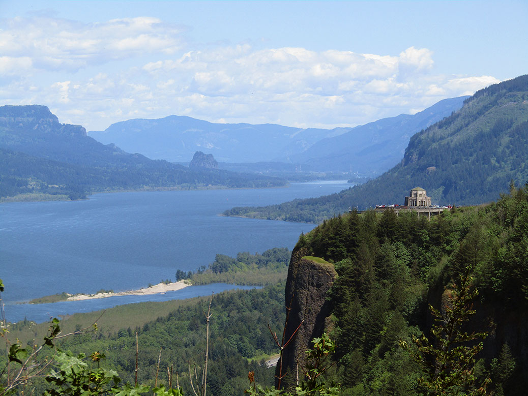
Our first stop was the Portland Women’s Forum State Scenic Viewpoint, providing the most photographed view of the Columbia River Gorge. Just up the road, the Vista House at Crown Point unofficially marks the beginning of the Gorge. Built in 1916-18 as a resting area for the new highway, it now houses an excellent museum featuring the natural and human history of the Gorge.
Continuing east on the HCRH, rows of cars begin to appear on the shoulder of the narrow two-lane road. The waterfalls in this stretch—the most concentrated in all of North America—are the main draw for day-trippers from Portland looking to hike the scenic trails or just stop for photos or a picnic. Many of the falls are accessible by a short walk from the road or nearby parking lots.

The biggest crowds are reserved for the magnificent Multnomah Falls. Oregon’s tallest waterfall drops in two parts—a long upper falls that collects into a basalt basin, giving way to a shorter lower falls. The best view is in front of the lower basin looking up at the footbridge, but a short walk up to the bridge is worthwhile.
Hiking to the top is a difficult march through steep switchbacks, but the views are worth it. You’ll also be rewarded with another waterfall—Little Multnomah—that can only be seen from the top.
From here, we followed the HCRH back to I-84 toward Hood River. Even on the modern freeway, there’s no shortage of sights along the way. The community of Bonneville is best known for the massive Bonneville Dam. Built in the 1930s as an initiative of the New Deal’s Public Works Administration, the dam provides power to more than 500,000 homes. It was named a National Historic Landmark in 1987.
Further up the river, the Bridge of the Gods crosses the Columbia River in the small city of Cascade Locks. The 90-year-old steel bridge gets its epic name from Klickitat tribe folklore, sharing its moniker with a land bridge created by a slide in 1100 A.D. The bridge also serves as the Columbia River crossing of the 2,659 mile-long Pacific Crest Trail, stretching from the Mexican border in California to the Canadian border in Washington.

We were ready to do some hiking of our own, although on a less grand scale than the PCT. Passing through Hood River, we quickly found ourselves at the payment window of the Hood River Toll Bridge without the requisite dollar for passage. A kind soul had left an extra dollar behind, covering our river crossing. On the way back—after a quick ATM stop—we left $2, one for our crossing and one to pay forward to the next forgetful traveler.
Click any photo in the gallery to see a larger version and start a slideshow view
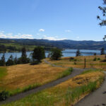

Having safely forded the river, we continued east on the Washington side through the city of Bingen toward Catherine Creek. The Catherine Creek Trailhead offers something for everyone, from a short 1.2 mile walk through the Universal Access Trail (UAT) to a long, hilly 8.2 mile out-and-back to Coyote Wall.
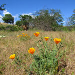
Before we left for our two-year journey in Japan, we’d hiked the West Loop trail and its spectacular views of the Gorge and nearby Rowland Lake. This time, we opted for the two-mile Arch Loop hike, but first, we walked the loop around the UAT. The paved interpretive trail is packed with great views of the Gorge and Mt. Hood. Dozens of varieties of wildflowers bloom at different times of the year, always offering a punch of color. Benches offer places to rest and enjoy the scenery and the entire trail is wheelchair-accessible.

After our warmup, we headed out the stone and gravel path toward the Arch Loop trail. The easy trail has a bit of incline as it winds through the light forest, across Catherine Creek and between tall stone cliffs. Opposite an abandoned corral is the trail’s namesake arch rock. The area is fenced off as it is a sacred area for the local Native American tribes.

We followed the trail up to the top of the arch rock where views of Mt. Hood and the Gorge fill the skyline. The flatlands at the top offer a great opportunity to explore or just sit and enjoy the views. Eventually, we left the vista behind, following the edge of the cliff until the trail picked up again. The last stretch was a bit underwhelming as we made our way down onto the highway for the final quarter-mile, but overall, Catherine Creek is an enjoyable stroll.
We crossed back to Oregon and headed into Hood River for a stop at one of our favorite breweries. Full Sail Brewing is the largest, yet still maintains a local feel at its brewery and taproom overlooking the Columbia River. Full Sail’s simple flagship beers are widely available, but it’s here in Hood River where the mastery of the craft really shines with a variety of seasonals and Brewmaster Reserve recipes always on tap.
After enjoying the seasonal sampler, we took a walk around the downtown area. Although quiet on the weekday evening, the charming and easily-walkable downtown is lively on the weekends with great local restaurants and shops. We finished up with one last pint and a pizza at Double Mountain Brewery before heading back toward Portland.

Perhaps the only view more stunning than the eastern vista on a sunny day is the western view on a clear evening. The sun began to set as we approached the viewpoint near the historical marker commemorating the British explorers of the H.M.S. Chatham in the 1790s. The fiery sky reflected off the calm waters of the river, slowly gradating to the indigo of the evening. A perfect ending to a great day in the Columbia River Gorge.
If You Go…
Portland Women’s Forum State Scenic Viewpoint
From I-84 E, take exit 22 and follow Corbett Hill Rd to the Historic Columbia River Highway.
Vista House at Crown Point
Follow the Historic Columbia River Highway east from the Portland Women’s Forum State Scenic Viewpoint.
Multnomah Falls
Follow the Historic Columbia River Highway east from Crown Point or take I-84 E to exit 31 (left-hand exit) for the Multnomah Falls parking lot.
Catherine Creek Trailhead
From I-84 E, take exit 64 near Hood River and turn left for Button Bridge Rd. Cross the toll bridge ($1 each way for most vehicles) and turn right on WA-14. Just before Rowland Lake, turn left onto Old Highway 8 to the trailhead parking.
Full Sail Brewing
506 Columbia St, Hood River. Open daily from 11 a.m.-9 p.m.
Double Mountain Brewery
8 4th St, Hood River. Open daily from 11 a.m.-10 p.m.