Smith Rock is the second in a series of posts on Cascadian Abroad focusing on the Seven Wonders of Oregon.
The sprawling plateau of central Oregon’s high desert region is one of North America’s great adventure sports destinations. Mt. Bachelor tests experienced snowboarders and skiers during the winters. The Deschutes River draws rafters, kayakers and paddleboarders all summer long. Sprawling trails offer mountain bikers, hikers and trail runners endless possibilities.
A few miles north of Bend—central Oregon’s largest city—Smith Rock calls rock climbers from around the globe to the precipitous cliffs of its volcanic tuff. Carved out over the course of 30 million years by a collapsed volcanic crater, lava flows and finally shaped by the aptly-named Crooked River, the formation stands out from the surrounding flat farmland.
Smith Rock is widely known as the sport climbing capital of the world. More than 500 climbing routes provide opportunities for beginners and elite climbers alike. However, it was the challenging hiking trails that led us to the rock on a warm and sunny spring day.

Even during the middle of the week, the ample parking area was full. A small interpretive center is surrounded by a shaded picnic area leading to the trailhead. Views from the top of the ridge are spectacular. The Crooked River winds through the formation while Mt. Washington with its distinctive pointed summit peeks out from a dip in the jagged rock.
Two paths lead from the parking area to the various trailheads. The subtle Canyon Trail takes a long loop along the rim walls down to the footbridge. The steep and rocky Chute is a straight shot for those hikers anxious to hit the trail.

Across the bridge, two family-friendly trails offer an easy walk with great views of the cliffs and a front-row seat to watch the dozens of climbers attached to the walls. The mile-long Wolf Tree Trail follows the north end of the canyon while the 2.5-mile River Trail heads south and provides the best look at the famous Monkey Face.

Wanting more of a challenge, we went straight ahead to the Misery Ridge Trail. The steep and rocky switchback trail is less than a mile to the top, but difficult as it covers 1,000 feet of elevation gain on a narrow trail. Along the way, tiny dots of climbers cling to any available wall, leaving our legs weak just looking at them.

We approached the summit of the Misery Ridge Trail, encountering a few climbers who took the “easy” way to the top. We looked back at the challenging climb from the stone plateau where the Crooked River meandered below. We dared ourselves to take in the view, staying a safe distance from the edge of the sheer cliff.

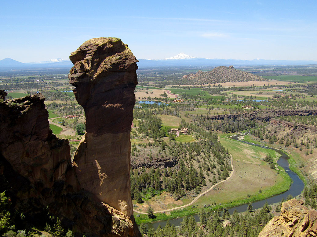
On the opposite side of the summit, the viewpoint opens up over the nearby cities of Redmond and Bend, all the way to the Cascade Mountain Range. We sat for awhile with a group of hikers from the Salem-area and watched as climbers tackled Smith Rock’s iconic Monkey Face.

Monkey Face is a 350-feet-tall rock spire that appears ready to topple at any time. Climbers ascend via multiple routes, including one known as Just Do It, considered one of the toughest free-climbing routes in the world. During our visit, the climbers descended over the monkey’s nose, resting on the mouth before dangling from their ropes and slowly lowering themselves to the rocks below.

Misery Ridge connects to the Mesa Verde Trail for the descent with equally-steep switchbacks over loose gravel. The slow shuffle to the bottom took about an hour to cover just a mile, although we stopped for awhile to try and capture a photo of a bald eagle that swooped overhead.

At the bottom, the trail levels out as it connects to the River Trail. We stopped repeatedly to take in the southern view of Monkey Face, where its namesake details are most visible. The River Trail expectedly follows the Crooked River back to the beginning of the trailhead.
Just when you think you’re done, a steep climb up The Chute or the Canyon Trail stands between you and your return to the top. We enjoyed a picnic lunch before making the long drive back to Portland.
If You Go…
Smith Rock State Park
From Bend, follow US-97 toward Terrebonne. Turn right on NW Smith Rock Way and left on NE 1st Street. Turn left on NE Crooked River Dr and follow the road to the parking area. Day use parking is $5 or free with an Oregon State Parks parking permit.
Misery Ridge Trail
3.7 miles, steep and rocky with about 1,000 feet of elevation gain. From the main parking lot, follow any trail toward the canyon. Take the Canyon Trail or The Chute across the footbridge and up the switchbacks at the trailhead marker. From the Monkey Face viewpoint at the summit, head down the left side toward the switchbacks connecting to the Mesa Verde Trail. As you approach the river, continue straight on the trail to connect to the River Trail and follow back to the trailhead at the footbridge.